Patricia and I took a road trip at the end of June. We wanted to visit Belvidere to help celebrate my Mom’s 90th birthday. Mary and Bill, Tom, and we were able to make our schedules work for the last weekend in June.
Lots more pictures on the pictures page for this post .
I think I can safely report that there were mostly highlights along the way. The man-eating bison herd in Custer state Park was a special highlight but the drive through downtown Cairo, Illinois was a definite lowlight. We decided to drive because we wanted to take a look at some of the territory we hadn’t seen from ground level before. We could have made a simple there-and-back trip of about 1,250 miles each way but we decided that if we were going to take a drive, we might as well take a DRIVE. We ended up travelling about 3,600 miles through 12 states: New Mexico, Texas, Oklahoma, Arkansas, Tennessee, Kentucky, Illinois, Iowa, Minnesota, South Dakota, Wyoming, and Colorado.
One soon forgets how green some of the states are after living in New Mexico for a while. It has been years since we drove through the Texas panhandle and Oklahoma and the parts we saw this time were very green with interesting vistas. We spent our first night on the road just east of Oklahoma City in the brand new Del City. We found a really good Mexican food restaurant called Ted’s Café Escondido. For some reason we had never thought of Oklahoma as a place where we would find good Mexican food.
We started out early the next morning because we wanted to arrive in Memphis as early as possible. The growth through Arkansas and southern Tennessee was green and lush. The traffic around Little Rock was terrible and the road construction made it worse. [It reminded us of the continual construction work on the Chicago freeways. I don’t think I have been to Chicago once in more that 40 years when there wasn’t construction somewhere between me and my destination.] Shortly after leaving the Little Rock environs and while we were congratulating ourselves on surviving the traffic mess, we began to see ominous road signs suggesting that we should find an alternate way to Memphis. We ignored the signs for a long time, but when we got off the freeway to get gas, we had to cross over the freeway. From the bridge we could see nothing but stopped traffic in our direction for miles. With the [false] confidence that maps and a GPS can inspire, we began to follow side roads the we believed would get us to Memphis. Unfortunately, many truck drivers had the same idea. The scenery was nice, however, and we had plenty of time to look at it. [I did not know that Arkansas is a leading producer of rice in the U.S.] Even with what seemed a long delay, we arrived in Memphis with plenty of time to walk around.
We had never been to Memphis and the only things I knew about it were the river, its place in the Civil War, and the Blues. We didn’t have time to see much of the city, but we were able to go down by the Mississippi and see the bridges and a river boat. But the big draw for us was walking up and down Beale Street.
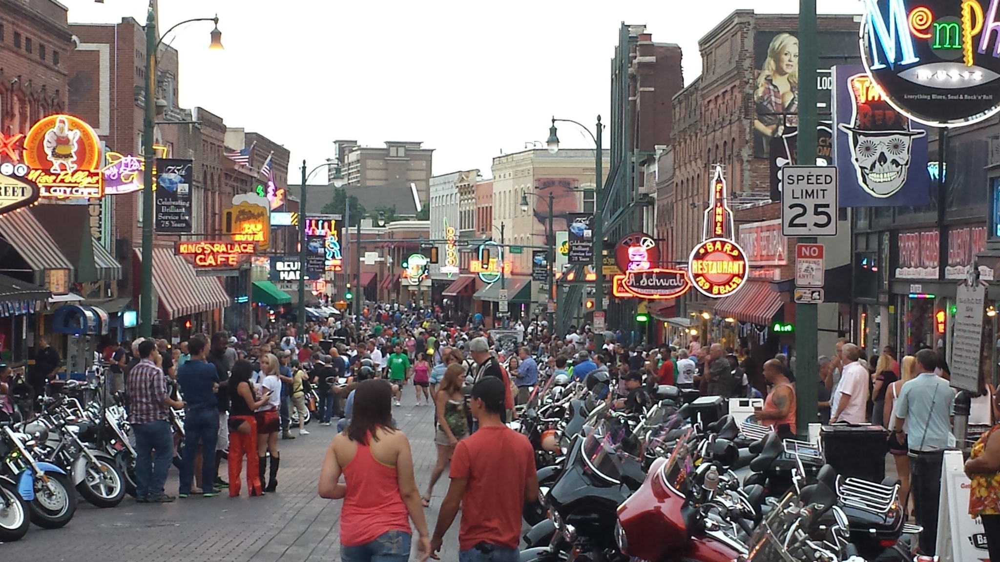
Beale Street is reputed to be the home of the blues (sorry, Chicago and Maxwell Street) and there is plenty of music there today. We found a CD store–not too many of those any more–and were re-introduced to Buddy Guy by a really enthusiastic sales person. I’d say that Beale Street is pretty much a tourist destination now, but there is still a lot of music to be heard there. We had dinner at B.B. King’s blues club. No B.B. King, of course, but some OK music. When we left the club, there were hundreds of motorcycles parked on the street and cruising down it. There were also a number of moderately strange people on the street along with a group of tumblers who did their act in the gaps between bikes. We deliberately took surface streets rather than the freeway when we left Memphis so we could get a look at the town.
Shortly before we got to Cairo, where the Ohio and the Mississippi meet, we stopped at the Wickliffe Mounds site. The mounds were part of Native American sites in the river valleys. Wickliffe (previously King) mounds are fairly small but they have done a good job with excavation and preservation. We were not allowed to take pictures inside the building with the most artifacts and excavations, but we saw a lot.

As I mentioned earlier, we drove through Cairo. The purpose of going to Cairo was to see the confluence of the Ohio and Mississippi rivers. I had been warned that the park that overlooks the confluence was probably not a place we wanted to spend any time so it was fortunate that one of the people at Wickliffe suggested that we go back down the road to find the Fort Jefferson Memorial Cross, from which we could get a good view of the place where the two rivers come together. We did get a good view and we saw the large cross as well.
From there we crossed the Ohio into Illinois and into Cairo. I mentioned that Cairo was a lowlight; that small down was one of the most depressing places we have seen. It looked as if most people had packed up and left some time ago. I’m glad we didn’t make it one of our overnight stops.
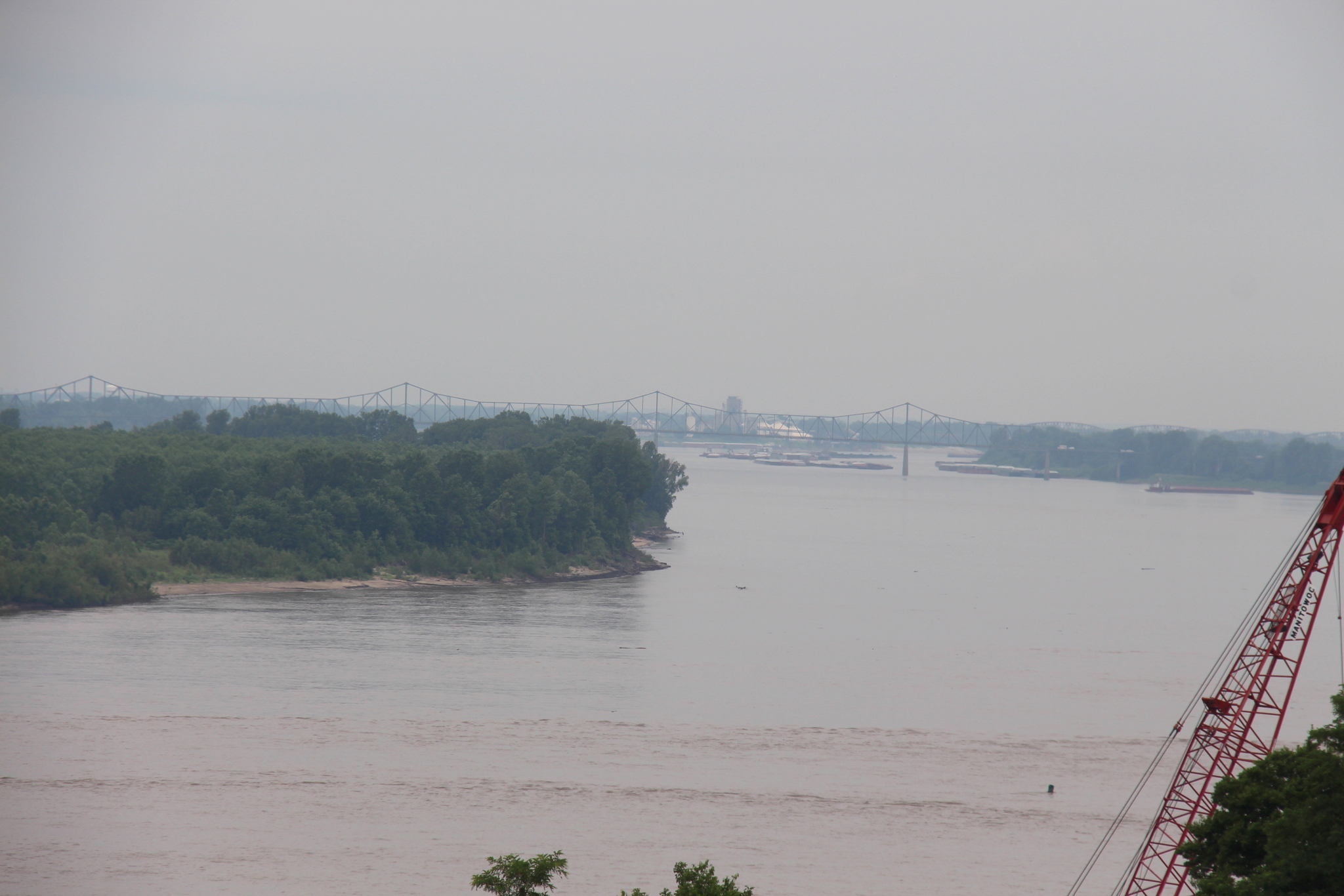
We followed the river road as much as possible and found a good place where we could walk down to the Mississippi to watch the barges and storm/flood debris go by. We used to watch barges when we lived a couple of blocks from the Ohio river in Belpre, Ohio and Parkersburg, West Virginia. We saw evidence of substantial flooding by the river.
We drove on several back roads to Collinsville, IL, where we spent the night. We chose that location so we would be close to the Cahokia Mounds State Historic Site. That is a very large site with many substantial mounds, one of which is more than 100 feet high. From the top of that mound I could see downtown St. Louis and the Gateway Arch. When I was young, I visited the Cahokia site with my family. The way I remembered it, there were still excavations going on. Now the site appears to be mostly restored and it has a great interpretive facility with displays of some of the artifacts found there. We really enjoyed visiting that site.
The drive from Collinsville to Rockford was fairly easy. We had one of our best visits with my parents. There was time for conversation and food and things weren’t too rushed until Sunday when lots of there was quite a crowd at their house.
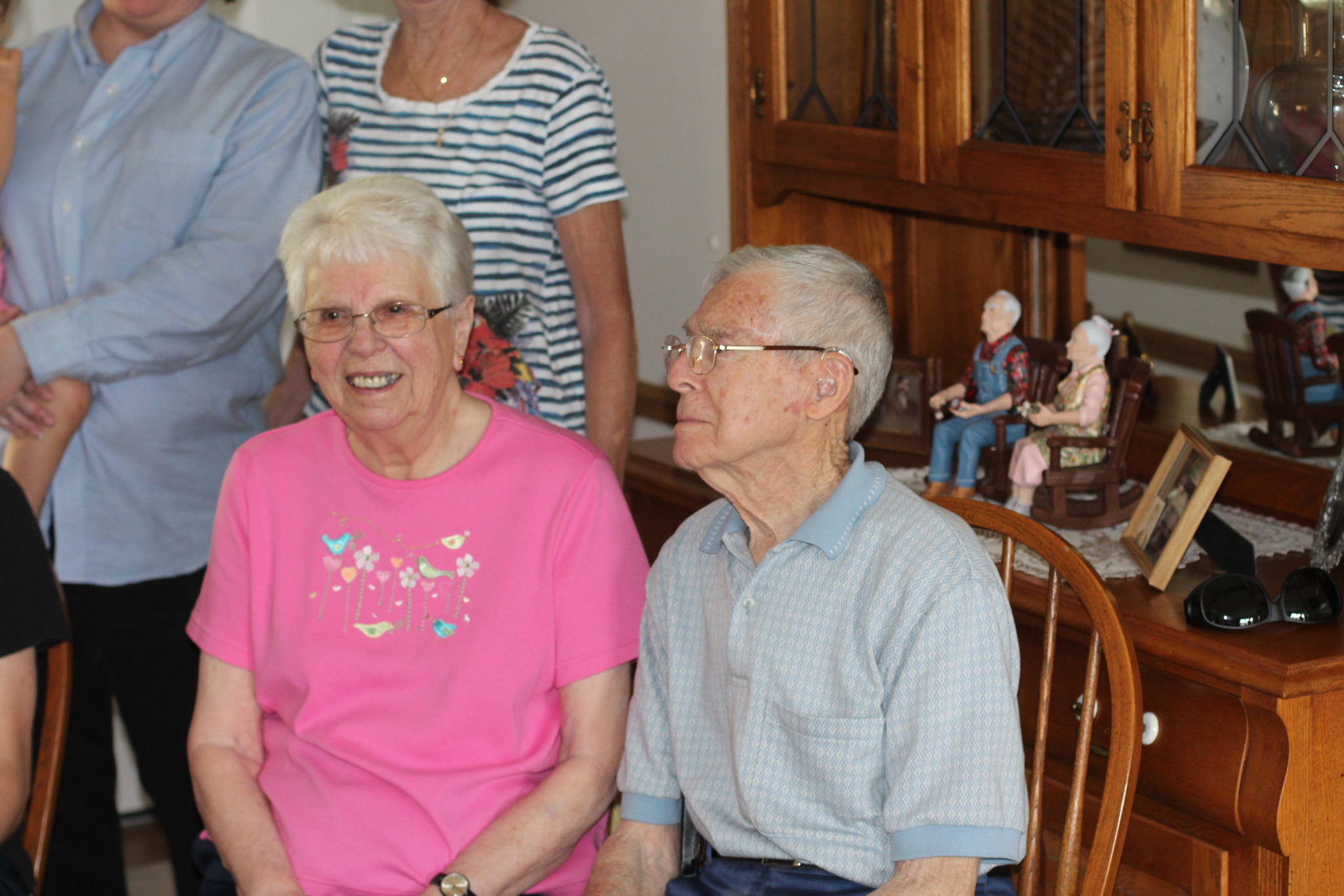
Mary and Bill were there along with ALL of their children and most of their grandchildren and if I kept track properly, great grandchildren. Mark and Tom were there. Debra came down for a while on Saturday. We got to visit with my aunt Joy, whome we see too infrequently. A very nice three days.
On Monday we set out for the Black Hills. Patricia had never seen any of South Dakota and since we were already on the road… We drove through Iowa and Minnesota and encountered some pretty bad weather that day. We saw a lot of flooded fields and wondered how badly the long stretch of bad weather was going to affect crops. We spent the night in Sioux Falls, SD. Who knew that it is the largest city in South Dakota? I didn’t. Of course, “large” is relative: the population is about 160,000. The little bit we saw of Sioux Falls seemed nice and we found a good Chinese food restaurant which was a treat after a long day of driving.
Most of Tuesday was spent on the road getting to Custer State Park, near Rapid City. We stopped for gas in Mitchell, but I was unable to persuade Patricia to visit the world-famous Corn Palace. We drove into strong winds all day long. We were buffeted for hours. As we neared the Missouri river we saw a beautiful rainbow that lasted for a long time. Perhaps because of the rain the parts of South Dakota we saw were spectacularly beautiful with green hills and lots of wildflowers. The Missouri river and the river valley were impressive. We stopped at the Badlands National Park for a while. It was pretty neat, but nothing like I remembered. It was a much bigger area in my memory. We made our way into Custer State Park which was green and lush. One of my memories of the park from my last trip there 49 years ago were the buffalo that wandered freely. We had only been in the park for a few minutes when we came up on a “traffic jam” of 10 or 12 cars.
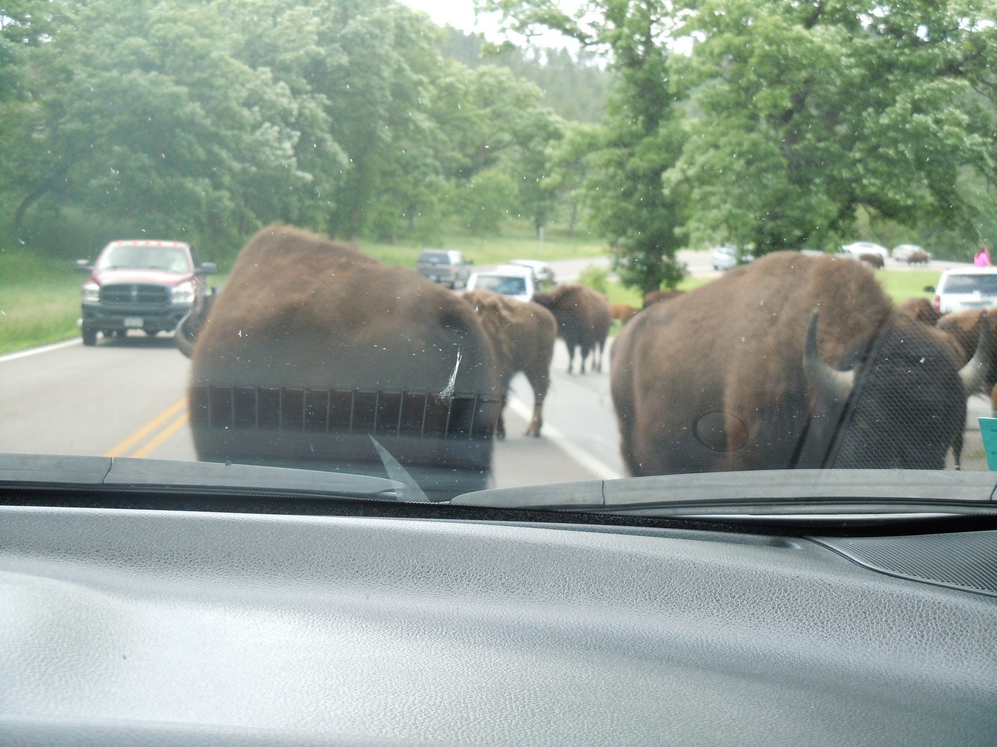
The road was being blocked by a small group (40 or 50) of buffalo who were taking their time as they moved from place to place. They were big and they seemed to like to come up to cars and look inside. I think Patricia thought they were going to eat her but we survived.
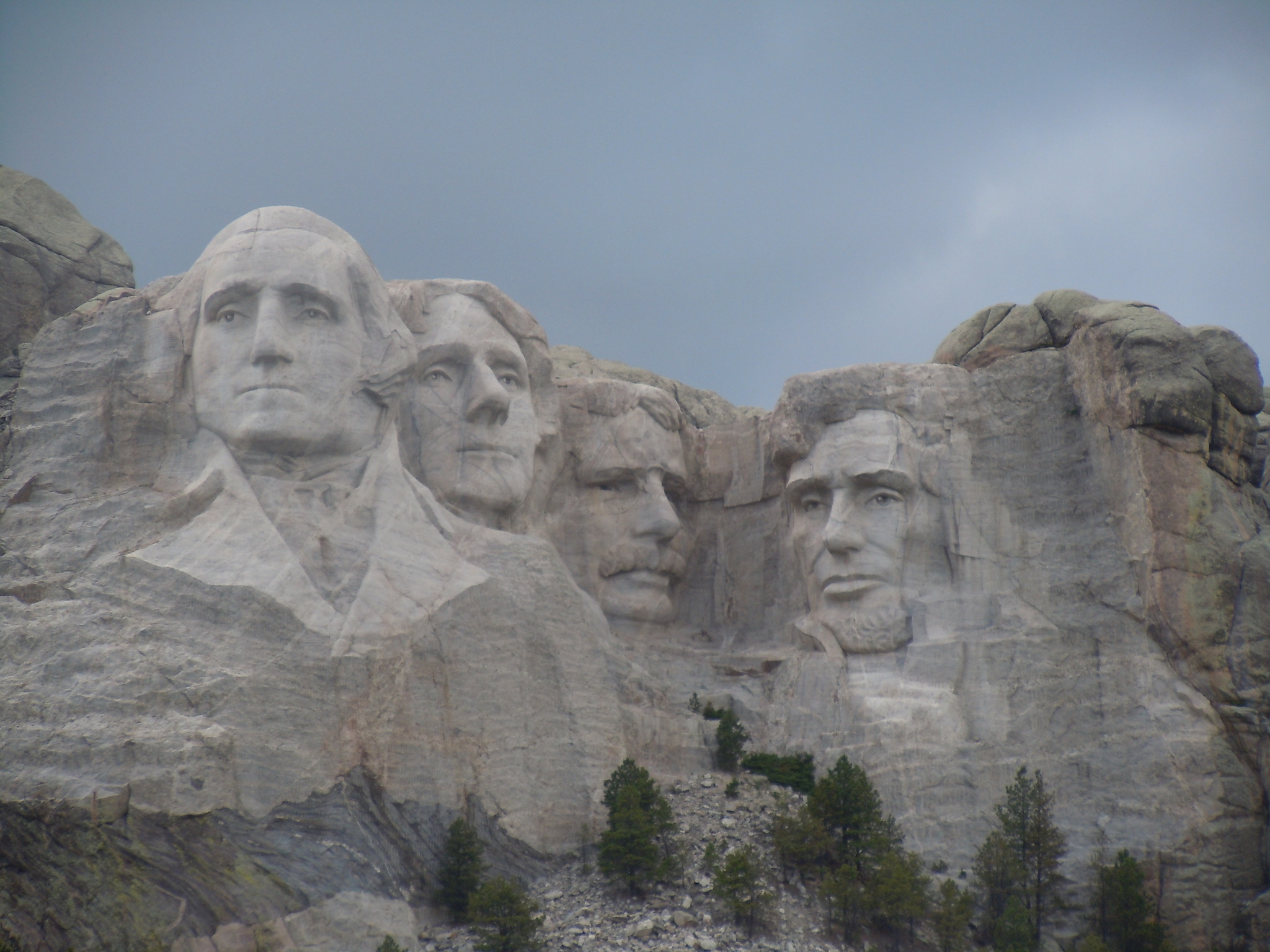
We visited Mount Rushmore Tuesday afternoon. There was not much traffic on the winding road to the site. While the monument itself was in the same place (and looked the same) as when I saw it in 1965, nothing else was familiar. There is a very nice visitor center and a new viewing area and even an amphitheater. The monument and setting were as impressive as I remembered. We were able to get lots of good pictures there.
On Wednesday we drove from Custer to Devil’s Tower in Wyoming. Devil’s Tower is another place I remember from that long-ago trip and another place Patricia had not yet seen. Getting there proved to be a small adventure in itself. Once again we chose to stay off the main roads and we took the scenic route. As a consequence, we spent a good bit of time in construction areas and driving on ripped up roads. Nevertheless, what we saw on the way and at Devil’s Tower made the construction delays tolerable.
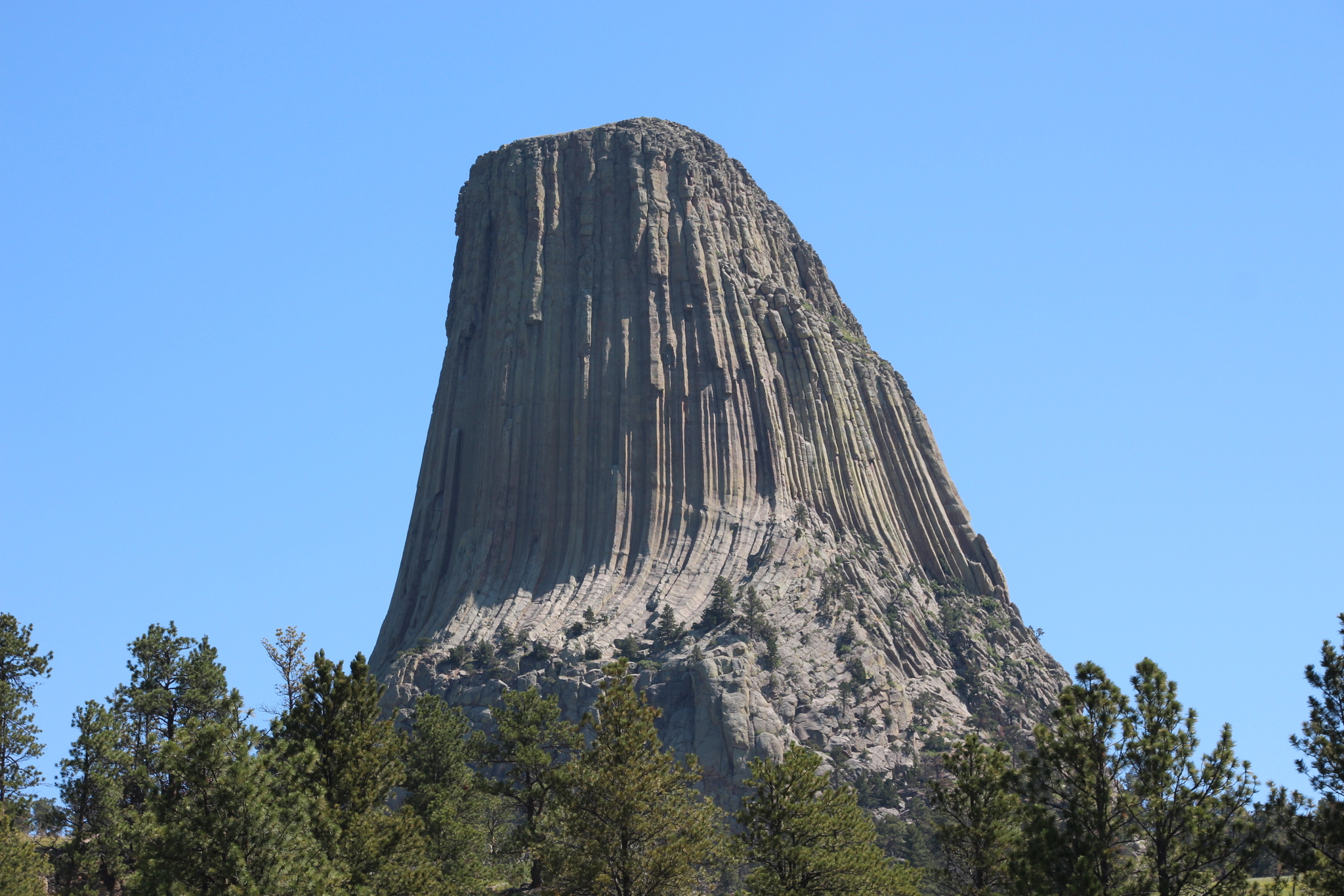
The weather near Devil’s Tower was very nice. The sky was blue, the temperature was pleasant, and the winds were mild. Those conditions made this standalone formation look even more impressive. This is the formation that was used in the movie “Close Encounters of the Third Kind.” One wonders how such a formation could be created and there are multiple explanations, none of which can be considered conclusive. Quoting from the National Park Service website
“The simplest explanation is that Devils Tower is a stock—a small intrusive body formed by magma which cooled underground and was later exposed by erosion.
The magma which formed Devils Tower cooled and crystallized into a rock type known as phonolite porphyry. It is a light to dark-gray or greenish-gray igneous rock with conspicuous crystals of white feldspar. Hot molten magma is less dense and occupies more volume than cool hardened rock. As the rock cooled, it contracted, forming hexagonal (and sometime 4-, 5- and 7-sided) columns separated by vertical cracks. These columns are similar to those found at Devil’s Postpile National Monument in California but those at Devils Tower are much larger.”
Whatever the science behind its creation, it is a wondrous sight. One of the places we stopped for pictures of the tower was home to many prairie dogs and we got some good pictures of them.
From Devil’s Tower we made the long drive to Cheyenne, where we spent our last night on the road. While I’m sure that Wyoming has some really nice scenery, we didn’t see much of it on this route. We did see mining and oil/gas operations and lots of trucks on the small highway we traveled (Highway 59) and I think we won’t go that way again.
The drive from Cheyenne to Santa Fe is about 500 miles and is pretty easy. We were glad to be back home even though we enjoyed our trip very much. We are looking forward to visiting South Dakota again.
Lots more pictures on the pictures page for this post .