On Saturday we took a day trip to the Connemara area of western Ireland. It is part of the tourist route known as the Wild Atlantic Way. As Patricia says, this was some of the most beautiful country we have ever seen.
It is [definitely] fall here and many of the trees have dropped their leaves. It has been cloudy, with spotty rain, and quite windy, but it has not dampened our enthusiasm for getting out to see more of Ireland, whether in the cities or, as in this case, the countryside. Last Sunday, when we travelled to the Wicklow Mountains, we could hardly see anything for the first half of the trip. On our bus tour of Connemara, we could see for miles and miles. Most of the trip was inland from the Atlantic Ocean, and west and north of Galway. This is another trip for us where words won’t tell you what we saw and pictures will be unable to convey the scale and beauty of the land.
The bus was late and I was thinking that I hoped that wasn’t an omen of how the trip was going to be. But Seamus, our driver / guide quickly got us loaded (on the bus, not with drink), and we were soon out of Galway city, and into County Galway. Once we got past the suburbs, the whole vista opened up and we could begin to see the mountains of the Twelve Bens Mountain range. The mountains near here aren’t terribly high by New Mexico standards, but Diamond Hill—which is an easy climb, we were told—is about 1,450 feet and Benbaun is about 2,400 feet. But they seem to tower over the landscape. The geology is quartzite and Dalradian schist. They are really old and were once part of the Pangean mountain range which included what is now the Appalachians, the Atlas in Morocco, and the Scottish Highlands. We have now been to all 4 parts of that ancient mountain range.
We stopped at an Irish fjord called Killary Fjord. It was carved by a glacier and leads from the little town (village?) of Leenaun out to the Atlantic, 16 kilometers away. We drove along the fjord for some distance and were told that in the summer there were boat tours every day. Speaking of summer, we have been told several times on this visit to Ireland that winter is right around the corner. In the Celtic calendar, winter begins around Samhain (Halloween) and at this point we are ready to believe that winter is not only coming, but it may have already arrived. We had some rain while we were in Leenaun but it stopped while we were driving along the fjord.
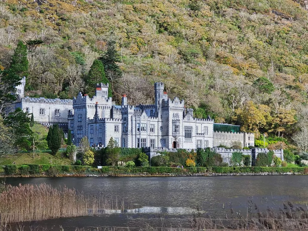
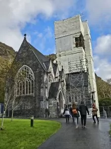
Our second stop was at Kylemore Abbey. There is history to what is now known as Kylemore Abbey that dates back to the 1860s, and not all of the history is happy. When I set up to tour, I thought that a stop to see some old place built by a rich guy to indulge his whims was going to be boring, but I hadn’t read the history at that point. Kylemore is built in an absolutely beautiful location which is actually improve by the building, which is often not the case. Check out the Wikipedia link above to get a short version of the history. The grounds (compound? I don’t have a good single word to describe it) now belong to an order of Benedictine nuns and they have turned the house into an exhibit. I found the exhibit to be informative. No sooner had we arrived than the rain started again. Not heavy rain, but with the wind blowing at approximately 900 miles an hour, it was annoying as we walked the grounds. After Mitchell Henry’s wife died in 1874, he had a Gothic-like church built on the grounds. The church is now getting a thorough restoration but we were able to go in and look. There is only one stained glass window, but there are examples of the 4 main kinds of marble found in Ireland.
Walking back to the visitor center was a challenge not because of the weather, but because there was so much to look at and so many pictures to take. IT was good to get inside and have so hot tomato-basil soup for a late lunch. [They say something like toe-MAH-toe bah-zil) for the soup.]
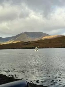
Our next leg of the drive was to a stop along the side of the road which Google Maps names the Lough Inagh Viewpoint. There are only small farms nearby, and no commercial businesses around. The view of the lake (Lough Inagh) and mountains was spectacular. Remember that I slightly exaggerated how hard the wind was blowing at Kylemore? It really was blowing hard at this viewpoint. In fact, it was blowing so hard that I could hardly hold my camera still for long enough to take pictures. Another reason for the stop is that the viewpoint is set on an area of bogland that has been, and still is, used for peat gathering. It was interesting to walk on what Seamus called “squidgy” ground and to see how the peat was cut from the land.
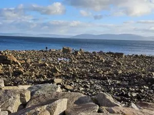
Our last stop was at Spidal (or Spiddle or, in Irish, An Spidéal) is a village on the norther side of Galway Bay. If you look at a map, you will see that we made a big loop from Galway, through Connemara, and back to Galway. Spidal stretches along the bay, and not far inland. It is well-known for arts and crafts and as a place to vacation. Our stop there was short, but just to be consistent, it rained a bit while we were stopped. I was able to get a couple of pictures, but, just like the rest of the pictures, it is difficult to capture the space, the colors, and the overall beauty of these areas.
We arrived back in Galway City in time. We were tired, but this was a very enjoyable trip. Had we not stopped anywhere on the route, it would have been enjoyable for just the scenery and the information Seamus passed on. We have been fortunate with our excursions on this trip. We have seen things we had not seen before, met interesting people, and learned a lot of history—both about Ireland and other places.